
 Asset Publisher
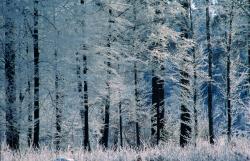
Polish forests
 fot. Paweł Fabijański
 fot. Paweł Fabijański
 fot. Paweł Fabijański
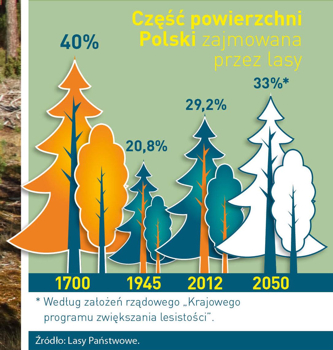
Poland is in the European lead, while concerning the area of all forests. They cover about 29,2 % of the country territory, and grow within the area of 9,1 million hectares. The overwhelming majority of the forests is state owned, of which almost 7,6 million hectares are managed by the State Forests National Forest Holding..
The number of Polish forest is still growing. The forestation rate of the country has increased from 21 % in 1945 to 29,2 % at the moment. Between 1995 and 2008, the forest area increased by 310 thousand ha. The basis for afforestation works is the "National Programme for Increasing the Forest Cover" (KPZL), assuming an increase of the forestation rate up to 30 % by 2020 and up to 33 % by 2050. Polish forests abound in flora, fauna and fungi. 65 % of the total number of animal species live there.
The forests grow in our country on poor soils, mainly because of the development of the agriculture in previous years. It influences the distribution of the types of the forest sites in Poland. Over 55 % of the forest areas is covered with coniferous forests. In other areas, there are forest sites, mainly the mixed ones. Their small part constitute alder and riparian forests – not more than 3 %.
In the years 1945 – 2011 the area of natural deciduous tree stands within the area of the State Forests National Forest Holding increased from 13 to 28,2 %.
Within the lowlands and uplands the most often occurring tee species is pine. It covers 64,3 % of the forest area of the State Forests National Forest Holding and 57,7 % of private and commune forests. In the mountains the predominant species is European spruce ( in the west) and European spruce with beech (in the east). Domination of pine is the result of carrying on sustainable forest management in the past. Once, the monocultures (crops or cultivations of one species) were the answer to the great demand of industry for wood. Such forests appeared to be quite fragile to climatic factors. They also were often the prey of pests' expansion.
In Polish forests, the share of other tree species, especially deciduous trees have been systematically increasing. The foresters have stepped aside from monocultures – that is why, they try to fit specific species of the forest stand to the natural stand, that would be proper for the given area. Thanks to that, in the years 1945 – 2011, the area of the deciduous tree stands within the lands of the State Forests National Forest Holding increased from 13 to 28,2 %. There occur more and more frequently the following tree species: oaks, ashes, maples, sycamore maples, elms, but also birches, beeches, alders, poplars, hornbeams, aspens, tilias and willows.
Our forests are the most often represented by the forest stands aged 40 to 80 years. The average age of the forest equals 60 years. More and more trees are of big size at the age over 80 years. Since the end of the Second World War, the forests' area has increased up to almost 1,85 million hectares.
Raport o stanie lasów w Polsce 2012
Asset Publisher


Asset Publisher
Lasy nadleśnictwa
Lasy nadleśnictwa

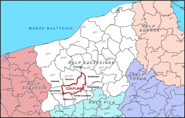
Nadleśnictwo Czaplinek zarządza w imieniu Skarbu Państwa lasami państwowymi na powierzchni 17,72 tyś. ha na obszarze dwóch obrębów – Czaplinek i Piława.
Nadleśnictwo Czaplinek jest Nadleśnictwem dwuobrębowym (Piława i Czaplinek). Podlega Regionalnej Dyrekcji Lasów Państwowych w Szczecinku. Obszar Nadleśnictwa graniczy z następującymi jednostkami LP: od północnego zachodu z Nadleśnictwem Świdwin, od północy – z Nadleśnictwem Połczyn, od wschodu – z Nadleśnictwem Szczecinek i z Nadleśnictwem Czarnobór, od południa – z Nadleśnictwem Borne Sulinowo
i Świerczyna, od zachodu – z Nadleśnictwem Złocieniec.
Zasięg terytorialny Nadleśnictwa Czaplinek ustalony został Zarządzeniem Nr 65 Dyrektora Generalnego Lasów Państwowych z dnia 05 września 2018 r.
Siedziba Nadleśnictwa znajduje się w miejscowości Czaplinek na ul. Kalinowej 1, w oddz. 162A-k ( obręb Czaplinek ).
Zestawienie powierzchni lasów znajdujących się w terytorialnym zasięgu Nadleśnictwa

Zasięg terytorialny Nadleśnictwa, to obszar o powierzchni 499,42 km2 i lesistości 34,7%. Nadleśnictwo położone jest w środkowej części województwa zachodniopomorskiego, w powiatach: drawskim, szczecineckim i świdwińskim (niewielki fragment bez gruntów w zarządzie Nadleśnictwa Czaplinek).
W zasięgu terytorialnym Nadleśnictwa Czaplinek znajduje się 804,12 ha lasów niestanowiących własności Skarbu Państwa, w tym: 786,71 ha – osób fizycznych, 17,41 ha – osób prawnych. Nadleśnictwo nie sprawuje nad nimi nadzoru.
Ponad połowa lasów Nadleśnictwa Czaplinek (61,7%) skupiona jest w 2 dużych kompleksach o powierzchni w przedziale „powyżej 2000,00 ha". Jednakże najwięcej jest kompleksów małych, do 5,00 ha (łącznie – 156); zajmują one 1,5% powierzchni wszystkich lasów Nadleśnictwa. Stosunkowo dużo jest też kompleksów od 5,01 do 20,00 ha (30) oraz od 20,01 do 100,00 ha (22). Łącznie kompleksy od 5,01 ha do 100,00 ha zajmują 7,2% powierzchni. Ogólnie można stwierdzić, że rozdrobnienie lasów Nadleśnictwa Czaplinek jest duże. Grunty leśne skupiają się w 217 kompleksach. Średnia powierzchnia kompleksu wynosi 67,68 ha
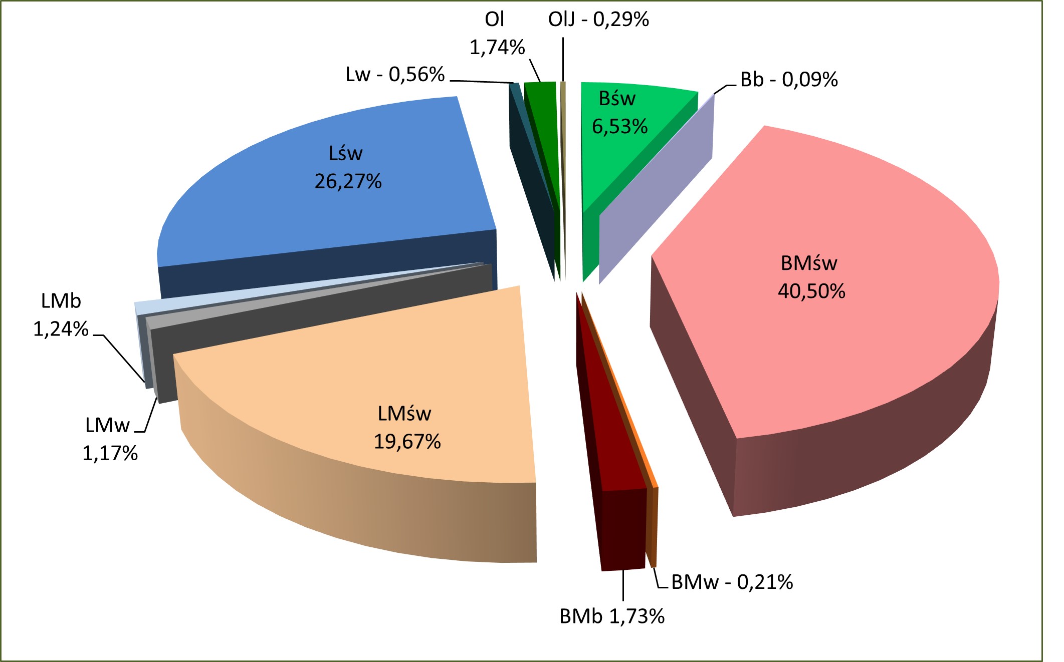
W Nadleśnictwie Czaplinek wyróżniono na gruntach leśnych 12 typów siedliskowych lasu. Głównymi typami są: BMśw – 6537,57 ha (40,50%), Lśw – 4240,14 ha (26,27%), LMśw – 3175,88 ha (19,67%) i Bśw – 1053,37 ha (6,53). Pozostałe siedliska zajmują w sumie 7,03%, w tym: 1,74% (280,52 ha) – Ol; 1,73% (279,04 ha) – BMb; 1,24% (200,86 ha) – LMb; 1,17% (188,97 ha) – LMw. Reszta (Lw, OlJ, BMw i Bb) nie ma w Nadleśnictwie większego znaczenia gospodarczego. W obrębie Piława największą powierzchnię zajmuje BMśw – 49,58%, a następne w kolejności są LMśw – 17,63% i Lśw – 16,49%. Natomiast w obrębie Czaplinek największą powierzchnie zajmuje Lśw – 40,99%, BMśw – 26,84% i LMśw – 22,75%.
Siedliska borowe zajmują w Nadleśnictwie 49,06% powierzchni gruntów zalesionych
i niezalesionych:
– obrębie Piława – 61,44%,
– w obrębie Czaplinek – 30,41%;
a siedliska lasowe 50,94%:
– w obrębie Piława – 38,56%,
– w obrębie Czaplinek – 69,59%.
Przyjmując za kryterium warunki wilgotnościowe, siedliska suche i świeże zajmują:
– w Nadleśnictwie – 92,97%,
– w obrębie Piława – 92,85%,
– w obrębie Czaplinek – 93,16%;
siedliska wilgotne:
– w Nadleśnictwie – 1,94%,
– w obrębie Piława – 1,45%,
– w obrębie Czaplinek – 2,67%;
siedliska bagienne i zalewowe:
– w Nadleśnictwie – 5,09%,
– w obrębie Piława – 5,70%,
– w obrębie Czaplinek – 4,17%.
Udział typów siedliskowych lasu w Nadleśnictwie Czaplinek
Siedliska naturalne i zbliżone do naturalnego zainwentaryzowano na powierzchni 4848,83 ha, co stanowi 30,04% powierzchni gruntów zalesionych i niezalesionych, w tym:
– w obrębie Piława – 2287,21 ha (23,59%),
– w obrębie Czaplinek – 2561,62 ha (39,75%).
Siedliska zniekształcone zainwentaryzowano na powierzchni 11292,83 ha, co stanowi 69,96% powierzchni gruntów zalesionych i niezalesionych, w tym:
– w obrębie Piława – 7409,84 ha (76,41%),
– w obrębie Czaplinek – 3882,99 ha (60,25%).
Siedliska przekształcone, zdegradowane i zdewastowane nie występują.
Głównym powodem zniekształcenia siedlisk jest porolność gleb, którą wyróżniono na 9973,32 ha (61,79%) gruntów zalesionych i niezalesionych (w tym 9901,96 ha w d-stanach).
– w obrębie Piława – 7090,66 ha (73,12%), w tym 7041,86 ha w d-stanach,
– w obrębie Czaplinek – 2882,66 ha (44,73%), w tym 2860,10 ha w d-stanach.
Zalesienia porolne wyodrębniono na 9142,93 ha, to jest na 57,24% powierzchni grun-tów zalesionych, w tym:
– w obrębie Piława – 6371,31 ha (66,42%),
– w obrębie Czaplinek – 2771,62 ha (43,43%).